
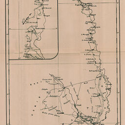
Course of the River Juba.
Permalink
https://digital.library.illinois.edu/items/45bb5190-e946-0133-1d3d-0050569601ca-c
This item is in the public domain.
Descriptive Information
| Title | Course of the River Juba. |
| Date | 1899 |
| Dimensions | 34.5 x 21.2 cm |
| Place of Publication | England |
| Cartographic Scale | 1:995,000 |
| Notes | Relief shown by hachures. Northern section inset. Reduced from a map published by the Intell. Div. War Office. |
| Coverage-Spatial | Juba River (Ethiopia and Somalia) |
| Subject | |
| Genre | Maps |
| Language | English |
| Color | Bitonal |
| Technique | Lithography |
| Source | The Geographical Journal, V. 14, between pp. 696-697. |
| Physical Location | stx |
| Map No. in Bassett and Scheven Bibliography | 1554 |
| Call Number | 910_5GJ |
| Map ID | afm0001554 |
| Rights | No Copyright - United States |
| Rights Description | This item is in the public domain. |
| Collection Title | Maps of Africa to 1900 |
| Repository | Rare Book & Manuscript Library |
| Type | Cartographic material |
| Collection | Maps of Africa to 1900 |
Download Options
|
Course of the River Juba. |
Contact us
for questions and to provide feedback.