
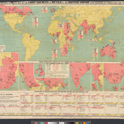
Imperial Institute map of the chief sources of metals in the British Empire, with diagrams of production for 1918
Permalink
https://digital.library.illinois.edu/items/45f91d90-b096-0136-5269-0050569601ca-a
No Copyright - United States
Descriptive Information
| Title | Imperial Institute map of the chief sources of metals in the British Empire, with diagrams of production for 1918 |
| Creator | Imperial Institute (Great Britain) |
| Contributor | |
| Scale | Scale [ca. 1:80,000,000]. |
| Place of Publication | London (England) |
| Publisher | |
| Date of Publication | 1918 |
| Extent | 1 map |
| Dimensions | 43 x 198 cm on sheet 92 x 117 cm |
| Notes |
|
| Coverage-Spatial | Great Britain |
| Language | English |
| Subject | Mines and mineral resources |
| Genre | Maps |
| Rights Description | No Copyright - United States |
| Type | Cartographic material |
| Repository | Map Library |
| Local Bib ID | 3998165 |
| Collection Title | World War I Maps |
| Collection | World War I Maps |
Download Options
|
Imperial Institute map of the chief sources of metals in the British Empire, with diagrams of production for 1918 |
Contact us
for questions and to provide feedback.