
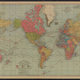
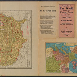
Complete map of the world with special map of Western Europe showing the German Barred Zones and safety lanes and the United States giving the various military departments, Army posts, Navy yards, etc.
Permalink
https://digital.library.illinois.edu/items/46045e50-b096-0136-5269-0050569601ca-0
No Copyright - United States
Descriptive Information
| Title | Complete map of the world with special map of Western Europe showing the German Barred Zones and safety lanes and the United States giving the various military departments, Army posts, Navy yards, etc. |
| Contributor | C.S. Hammond & Company |
| Scale | |
| Coordinates |
|
| Place of Publication | Boston (Mass.) |
| Publisher | Cheney, Fredrick A. |
| Date of Publication | 1917 |
| Extent | 3 maps on 1 sheet |
| Dimensions | 33 x 50 cm, 15 x 20 cm, and 20 x 27 cm, on sheet 36 x 54 cm, folded to 18 x 9 cm |
| Notes |
|
| Coverage-Spatial | |
| Language | English |
| Subject | |
| Genre | |
| Rights Description | No Copyright - United States |
| Type | Cartographic material |
| Repository | Map Library |
| Local Bib ID | 7994794 |
| Collection Title | World War I Maps |
| Collection | World War I Maps |
Download Options
|
7994794-001 | |
|
7994794-002 |
Contact us
for questions and to provide feedback.