
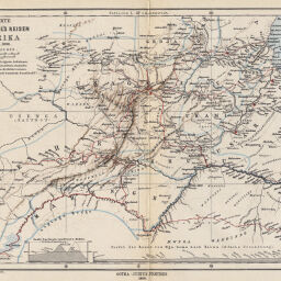
Originalkarte von Joachim Graf Pfeil's Reisen in Ost-Afrika, Okt. 1885 bis Febr. 1886
Permalink
https://digital.library.illinois.edu/items/46456ff0-e946-0133-1d3d-0050569601ca-a
This item is in the public domain.
Descriptive Information
| Title | Originalkarte von Joachim Graf Pfeil's Reisen in Ost-Afrika, Okt. 1885 bis Febr. 1886 |
| Creator | Perthes, Justus |
| Date | 1886 |
| Dimensions | 22.5 x 36 cm |
| Place of Publication | Germany |
| Cartographic Scale | 1:1,750,000 |
| Notes | Relief shown by landform drawings. Pfeil's route indicated in red. Includes 3 inset elevation profiles. |
| Coverage-Spatial | German East Africa |
| Subject | |
| Genre | Maps |
| Language | German |
| Color | Printed color |
| Technique | Lithography |
| Source | Petermanns geographische Mitteilungen, V. 32, plate 18. |
| Physical Location | stx |
| Map No. in Bassett and Scheven Bibliography | 1292 |
| Call Number | Q_910_5PE |
| Map ID | afm0001292 |
| Rights | No Copyright - United States |
| Rights Description | This item is in the public domain. |
| Collection Title | Maps of Africa to 1900 |
| Repository | Rare Book & Manuscript Library |
| Type | Cartographic material |
| Collection | Maps of Africa to 1900 |
Download Options
|
Originalkarte von Joachim Graf Pfeil's Reisen in Ost-Afrika, Okt. 1885 bis Febr. 1886 |
Contact us
for questions and to provide feedback.