
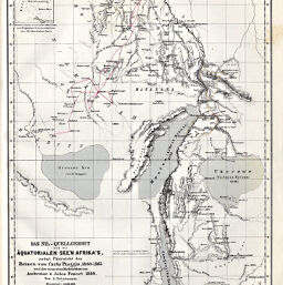
Das Nil-Quellgebiet und die Äquatorialen See'n Afrika's, nebst Übersicht der Reisen von Carlo Piaggia, 1860-1865...Ambroise & Jules Poncet, 1868
Permalink
https://digital.library.illinois.edu/items/47bd27d0-e946-0133-1d3d-0050569601ca-7
This item is in the public domain.
Descriptive Information
| Title | Das Nil-Quellgebiet und die Äquatorialen See'n Afrika's, nebst Übersicht der Reisen von Carlo Piaggia, 1860-1865...Ambroise & Jules Poncet, 1868 |
| Creator | Breithaupt, G. |
| Date | 1868 |
| Dimensions | 24.6 x 19 cm |
| Place of Publication | Germany |
| Cartographic Scale | 1:3,000,000 |
| Notes | Relief shown by hachures and spot heights. |
| Coverage-Spatial | Victoria, Lake |
| Subject | |
| Genre | Maps |
| Language | German |
| Color | Hand colored |
| Technique | Lithography |
| Source | Petermanns geographische Mitteilungenm, V. 14, plate 20. |
| Physical Location | stx |
| Map No. in Bassett and Scheven Bibliography | 1133 |
| Call Number | Q_910_5PE |
| Map ID | afm0001133 |
| Rights | No Copyright - United States |
| Rights Description | This item is in the public domain. |
| Collection Title | Maps of Africa to 1900 |
| Repository | Rare Book & Manuscript Library |
| Type | Cartographic material |
| Collection | Maps of Africa to 1900 |
Download Options
|
Das Nil-Quellgebiet und die Äquatorialen See'n Afrika's, nebst Übersicht der Reisen von Carlo Piaggia, 1860-1865...Ambroise & Jules Poncet, 1868 |
Contact us
for questions and to provide feedback.