
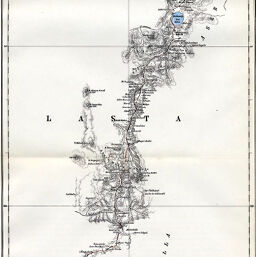
Karte der Englischen Aufnahmen in Abessinien, 1867 & 1868, Südliche Hälfte
Permalink
https://digital.library.illinois.edu/items/47fd06b0-e946-0133-1d3d-0050569601ca-9
This item is in the public domain.
Descriptive Information
| Title | Karte der Englischen Aufnahmen in Abessinien, 1867 & 1868, Südliche Hälfte |
| Date | 1869 |
| Dimensions | 52 x 19.5 cm |
| Place of Publication | Germany |
| Cartographic Scale | 1:450,000 |
| Notes | Relief shown by hachures, contours and spot heights. Includes 1 inset map: Umbegung von Macdala. See map No. 1141 in Bassett. |
| Coverage-Spatial | Āmba Maryam (Ethiopia) |
| Subject | |
| Genre | Maps |
| Language | German |
| Color | Hand colored |
| Technique | Lithography |
| Source | Petermanns geographische Mitteilungen, V. 15, plate 8. |
| Physical Location | stx |
| Map No. in Bassett and Scheven Bibliography | 1142 |
| Call Number | Q_910_5PE |
| Map ID | afm0001142 |
| Rights | No Copyright - United States |
| Rights Description | This item is in the public domain. |
| Collection Title | Maps of Africa to 1900 |
| Repository | Rare Book & Manuscript Library |
| Type | Cartographic material |
| Collection | Maps of Africa to 1900 |
Download Options
|
Karte der Englischen Aufnahmen in Abessinien, 1867 & 1868, Südliche Hälfte |
Contact us
for questions and to provide feedback.