
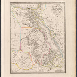
Carte du Cours du Nil Comprenant L'Egypte, La Nubie, L'Abyssinie et la Mer Rouge
Permalink
https://digital.library.illinois.edu/items/485182a0-c278-0135-4a00-0050569601ca-0
This item is in the public domain.
Descriptive Information
| Title | Carte du Cours du Nil Comprenant L'Egypte, La Nubie, L'Abyssinie et la Mer Rouge |
| Creator | Andriveau-Goujon, J. |
| Date | 1850 |
| Dimensions | 49.5 x 38 cm |
| Place of Publication | Paris (France) |
| Cartographic Scale | 1:6,000,000 |
| Coverage-Spatial | Africa, North |
| Genre | Maps |
| Source | Atlas de Choix, ou Recueil des Meilleures Cartes de Géographie Ancienne et Moderne Dressées par Divers Auteurs. Paris. Chez J. Andriveau-Goujon. 1854. |
| Physical Location | Professor Thomas Bassett Personal Collection |
| Bibliography | Rumsey No. 12050.059 |
| Map ID | afm0003307 |
| Rights | No Copyright - United States |
| Rights Description | This item is in the public domain. |
| Collection Title | Maps of Africa to 1900 |
| Repository | Rare Book & Manuscript Library |
| Type | Cartographic material |
| Collection | Maps of Africa to 1900 |
Download Options
|
Carte du Cours du Nil Comprenant L'Egypte, La Nubie, L'Abyssinie et la Mer Rouge |
Contact us
for questions and to provide feedback.