
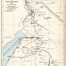
Kartenskizze zur Übersicht von Pascha Baker's in die Obern Nillander, 1870/2
Permalink
https://digital.library.illinois.edu/items/48534080-e946-0133-1d3d-0050569601ca-0
This item is in the public domain.
Descriptive Information
| Title | Kartenskizze zur Übersicht von Pascha Baker's in die Obern Nillander, 1870/2 |
| Creator | Hellfarth, D.C. |
| Date | 1873 |
| Dimensions | 24.5 x 19 cm |
| Place of Publication | Germany |
| Cartographic Scale | 1:2,100,000 |
| Notes | Relief shown by hachures and spot heights. |
| Coverage-Spatial | Nile River Watershed |
| Subject | |
| Genre | Maps |
| Language | German |
| Color | Hand colored |
| Technique | Lithography |
| Source | Petermanns geographische Mitteilungen, V. 19, plate 19. |
| Physical Location | stx |
| Map No. in Bassett and Scheven Bibliography | 1154 |
| Call Number | Q_910_5PE |
| Map ID | afm0001154 |
| Rights | No Copyright - United States |
| Rights Description | This item is in the public domain. |
| Collection Title | Maps of Africa to 1900 |
| Repository | Rare Book & Manuscript Library |
| Type | Cartographic material |
| Collection | Maps of Africa to 1900 |
Download Options
|
Kartenskizze zur Übersicht von Pascha Baker's in die Obern Nillander, 1870/2 |
Contact us
for questions and to provide feedback.