
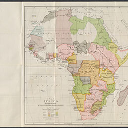
A Map of Africa Showing the Boundaries Settled by International Treaties & Agreements
Permalink
https://digital.library.illinois.edu/items/491b0cb0-c278-0135-4a00-0050569601ca-f
This item is in the public domain.
Descriptive Information
| Title | A Map of Africa Showing the Boundaries Settled by International Treaties & Agreements |
| Creator | Royal Geographical Society (Great Britain) |
| Date | 1890 |
| Dimensions | 41.6 x 40 cm |
| Place of Publication | London (England) |
| Cartographic Scale | 1:20,500,000 |
| Coverage-Spatial | Africa |
| Genre | Maps |
| Source | Proceeedings of the Royal Geographical Society, V. 12 , No. 11 |
| Physical Location | Professor Thomas Bassett Personal Collection |
| Bibliography | Bassett & Scheven, No. 390 |
| Map ID | afm0003314 |
| Rights | No Copyright - United States |
| Rights Description | This item is in the public domain. |
| Collection Title | Maps of Africa to 1900 |
| Repository | Rare Book & Manuscript Library |
| Type | Cartographic material |
| Collection | Maps of Africa to 1900 |
Download Options
|
A Map of Africa Showing the Boundaries Settled by International Treaties & Agreements |
Contact us
for questions and to provide feedback.