
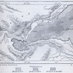
Baie de Tadjourah
Permalink
https://digital.library.illinois.edu/items/49364180-e946-0133-1d3d-0050569601ca-8
This item is in the public domain.
Descriptive Information
| Title | Baie de Tadjourah |
| Creator | Perron, Charles Eugène, 1837-1909 |
| Date | 1885 |
| Dimensions | 8.3 x 11.1 cm |
| Place of Publication | France |
| Cartographic Scale | 1:866,667 |
| Notes | Relief shown by landform drawings. Paris meridian. |
| Coverage-Spatial | Djibouti |
| Subject | |
| Genre | Maps |
| Language | French |
| Color | Bitonal |
| Technique | Lithography |
| Source | Revue de geographie, V. 16, p. 157. |
| Physical Location | stx |
| Map No. in Bassett and Scheven Bibliography | 1281 |
| Call Number | 910_5RE |
| Map ID | afm0001281 |
| Rights | No Copyright - United States |
| Rights Description | This item is in the public domain. |
| Collection Title | Maps of Africa to 1900 |
| Repository | Rare Book & Manuscript Library |
| Type | Cartographic material |
| Collection | Maps of Africa to 1900 |
Download Options
|
Baie de Tadjourah |
Contact us
for questions and to provide feedback.