


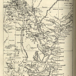
Eastern Equatorial Africa
Permalink
https://digital.library.illinois.edu/items/4945b610-e946-0133-1d3d-0050569601ca-f
This item is in the public domain.
Descriptive Information
| Title | Eastern Equatorial Africa |
| Creator | Johnston, Harry, 1858-1927 |
| Date | 1885 |
| Dimensions | 14 x 10.9 cm |
| Place of Publication | England |
| Cartographic Scale | 1:8,250,000 |
| Notes | Relief shown by hachures and spot heights. |
| Coverage-Spatial | Africa, East |
| Subject | |
| Genre | Maps |
| Language | English |
| Color | Bitonal |
| Technique | Lithography |
| Source | Scottish geographical magazine, V. 1, between pp. 144-145. |
| Physical Location | stx |
| Map No. in Bassett and Scheven Bibliography | 1272 |
| Call Number | 910_5SC |
| Map ID | afm0001272 |
| Rights | No Copyright - United States |
| Rights Description | This item is in the public domain. |
| Collection Title | Maps of Africa to 1900 |
| Repository | Rare Book & Manuscript Library |
| Type | Cartographic material |
| Collection | Maps of Africa to 1900 |
Download Options
|
Eastern Equatorial Africa |
Contact us
for questions and to provide feedback.