
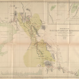
Route Map of the R.G.S. East African Expedition from Mombassa to Mt. Kenia and Victoria Nyanza Constructed from Mr. Jos. Thomsons Original Map
Permalink
https://digital.library.illinois.edu/items/49be62e0-e946-0133-1d3d-0050569601ca-5
This item is in the public domain.
Descriptive Information
| Title | Route Map of the R.G.S. East African Expedition from Mombassa to Mt. Kenia and Victoria Nyanza Constructed from Mr. Jos. Thomsons Original Map |
| Creator | Sharbau, H. (Henry) |
| Date | 1884 |
| Dimensions | 47.5 x 51.5 cm |
| Place of Publication | England |
| Cartographic Scale | 1:1,460,000 |
| Coverage-Spatial | Africa, Eastern |
| Genre | Maps |
| Source | Proceedings of the Royal Geographical Society, V. 6, No. 12, after p. 758. |
| Physical Location | rbx |
| Map No. in Bassett and Scheven Bibliography | 1262 |
| Call Number | 910_6RLn_s_ |
| Map ID | afm0001262 |
| Rights | No Copyright - United States |
| Rights Description | This item is in the public domain. |
| Collection Title | Maps of Africa to 1900 |
| Repository | Rare Book & Manuscript Library |
| Type | Cartographic material |
| Collection | Maps of Africa to 1900 |
Download Options
|
Route Map of the R.G.S. East African Expedition from Mombassa to Mt. Kenia and Victoria Nyanza Constructed from Mr. Jos. Thomsons Original Map |
Contact us
for questions and to provide feedback.