
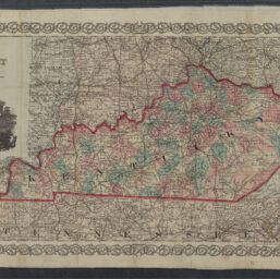
Colton's Kentucky
Permalink
https://digital.library.illinois.edu/items/4b854a40-0eca-013c-47d9-02d0d7bfd6e4-3
This item is in the public domain.
Descriptive Information
| Title | Colton's Kentucky |
| Creator | Colton, J. H. (Joseph Hutchins), 1800-1893 |
| Scale | Scale approximately 1:1,550,000 |
| Coordinates | W 89°35ʹ--/W 81°57ʹ/N 39°09ʹ--N 36°37ʹ |
| Place of Publication | New York (N.Y.) |
| Publisher | J.H. Colton & Co. |
| Date of Publication | 1860 |
| Extent | 1 map : color |
| Dimensions | 28 x 56 cm |
| Notes |
|
| Coverage-Spatial | Kentucky |
| Language | English |
| Genre | Maps |
| Rights | No Copyright - United States |
| Rights Description | This item is in the public domain. |
| Type | Cartographic material |
| Repository | Map Library |
| Local Bib ID | 99161288412205899 |
| Collection Title | Civil War Maps |
| Collection | Civil War Maps |
Download Options
|
Colton's Kentucky |
Contact us
for questions and to provide feedback.