
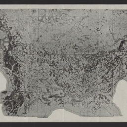
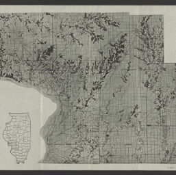
Forest map of Illinois
Permalink
https://digital.library.illinois.edu/items/4b874ba0-9935-013c-4aba-02d0d7bfd6e4-5
No Copyright - United States
Descriptive Information
| Title | Forest map of Illinois |
| Creator | Telford, C. J. (Clarence John), 1887- |
| Scale | Scale [ca. 1:250,000] |
| Coordinates | W 91°30ʹ--W 87°30ʹ/N 42°30ʹ--N 37° |
| Place of Publication | Urbana (Ill.) |
| Publisher | Illinois. Natural History Survey Division |
| Date of Publication | 1926 |
| Extent | 4 maps |
| Dimensions | 35 x 70 cm or smaller |
| Notes |
|
| Coverage-Spatial | Illinois |
| Language | English |
| Subject | Forests and forestry |
| Associated Entities | Illinois. Natural History Survey Division |
| Genre | |
| Rights | No Copyright - United States |
| Type | Cartographic material |
| Repository | Map Library |
| Local Bib ID | 99162325212205899 |
| Collection Title | 1920s Maps |
| Collection | 1920s Maps |
Download Options
|
99162325212205899-001 | |

|
99162325212205899-002 | |
|
99162325212205899-003 | |

|
99162325212205899-004 |
Contact us
for questions and to provide feedback.