
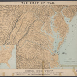
The seat of war : birds eye view of Virginia, Maryland, Delaware, and the District of Columbia
Birds eye view of Virginia, Maryland, Delaware and the District of Columbia
Permalink
https://digital.library.illinois.edu/items/4bb4f2f0-0eca-013c-47d9-02d0d7bfd6e4-d
This item is in the public domain.
Descriptive Information
| Title | The seat of war : birds eye view of Virginia, Maryland, Delaware, and the District of Columbia |
| Alternative Title | Birds eye view of Virginia, Maryland, Delaware and the District of Columbia |
| Creator | Schaus, W. (William) |
| Scale | Scale approximately 1:800,000 |
| Place of Publication | New York (N.Y.) |
| Publisher | |
| Date of Publication | 1861 |
| Extent | 1 map : color |
| Dimensions | 56 x 76 cm, on sheet 71 x 87 cm |
| Notes |
|
| Coverage-Spatial | |
| Language | English |
| Subject | American Civil War (United States : 1861-1865) |
| Associated Entities | |
| Genre | Maps |
| Rights | No Copyright - United States |
| Rights Description | This item is in the public domain. |
| Type | Cartographic material |
| Repository | Map Library |
| Local Bib ID | 99162353812205899 |
| Collection Title | Civil War Maps |
| Collection | Civil War Maps |
Download Options
|
The seat of war : birds eye view of Virginia, Maryland, Delaware, and the District of Columbia |
Contact us
for questions and to provide feedback.