
Africa
Permalink
https://digital.library.illinois.edu/items/4bbca080-e946-0133-1d3d-0050569601ca-b
This item is in the public domain.
Descriptive Information
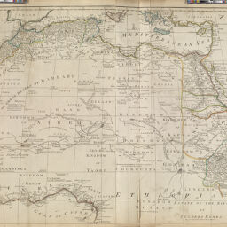
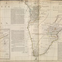
| Title | Africa |
| Creator | Sayer, Robert, 1725-1794 |
| Date | 1772 |
| Dimensions | Two sheets together: 103 x 121.5 cm |
| Place of Publication | London (England) |
| Cartographic Scale |
|
| Notes | The whole illustrated with a summary description relative to the trade and natural produce, manners and customs of that part of the world. Printed for Robert Sayer. |
| Coverage-Spatial | Africa |
| Genre | Maps |
| Physical Location | rbx |
| Map No. in Bassett and Scheven Bibliography | 104 |
| Call Number | G83001772_S3 |
| Map ID | afm0000104 |
| Rights | No Copyright - United States |
| Rights Description | This item is in the public domain. |
| Collection Title | Maps of Africa to 1900 |
| Repository | Rare Book & Manuscript Library |
| Type | Cartographic material |
| Collection | Maps of Africa to 1900 |
Download Options
|
Africa, according to Mr. Danville with several additions and improvement with a particular chart of the Gold Coast wherein are distinguished all the European forts and factories. | |
|
Chart of the Gold Coast - wherein are distinguished all the forts and factories belonging to the several European powers: Improved from Mr. Danville. |
Contact us
for questions and to provide feedback.