
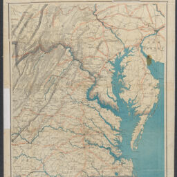
Map of eastern Virginia / compiled from the best authorities, and printed at the Coast Survey Office, A. D. Bache, Supdt. Compiled by W. L. Nicholson. Lith. by Chas. G. Krebs
Permalink
https://digital.library.illinois.edu/items/4bd0d3a0-0eca-013c-47d9-02d0d7bfd6e4-8
This item is in the public domain.
Descriptive Information
| Title | Map of eastern Virginia / compiled from the best authorities, and printed at the Coast Survey Office, A. D. Bache, Supdt. Compiled by W. L. Nicholson. Lith. by Chas. G. Krebs |
| Creator | Nicholson, W. L. |
| Scale | Scale [ca. 1:887,040] |
| Place of Publication | Washington (D.C.) |
| Publisher | United States. Government Publishing Office |
| Date of Publication | 1862 |
| Extent | 1 map : color |
| Dimensions | 62 x 48 cm |
| Notes |
|
| Coverage-Spatial | Virginia |
| Language | English |
| Genre | Maps |
| Rights | No Copyright - United States |
| Rights Description | This item is in the public domain. |
| Type | Cartographic material |
| Repository | Map Library |
| Local Bib ID | 99399014312205899 |
| Collection Title | Civil War Maps |
| Collection | Civil War Maps |
Download Options
|
Map of eastern Virginia / compiled from the best authorities, and printed at the Coast Survey Office, A. D. Bache, Supdt. Compiled by W. L. Nicholson. Lith. by Chas. G. Krebs |
Contact us
for questions and to provide feedback.