
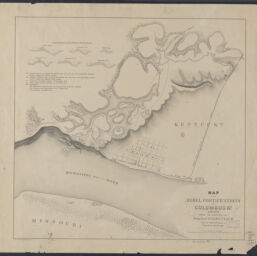
Map of the Rebel fortifications at Columbus, Ky. / surveyed under the direction of Brig. Genl. Geo. W. Cullum
Permalink
https://digital.library.illinois.edu/items/4bdd41b0-0eca-013c-47d9-02d0d7bfd6e4-9
This item is in the public domain.
Descriptive Information
| Title | Map of the Rebel fortifications at Columbus, Ky. / surveyed under the direction of Brig. Genl. Geo. W. Cullum |
| Creator | Cullum, George W. (George Washington), 1809-1892 |
| Scale | Scale 1:7,200. 600 feet to one inch |
| Place of Publication | New York (N.Y.) |
| Publisher | |
| Date of Publication | 1862 |
| Extent | 1 map |
| Dimensions | 45 x 47 cm |
| Notes |
|
| Coverage-Spatial | |
| Language | English |
| Subject | |
| Associated Entities | |
| Genre | Maps |
| Rights | No Copyright - United States |
| Rights Description | This item is in the public domain. |
| Type | Cartographic material |
| Repository | Map Library |
| Local Bib ID | 99399113612205899 |
| Collection Title | Civil War Maps |
| Collection | Civil War Maps |
Download Options
|
Map of the Rebel fortifications at Columbus, Ky. / surveyed under the direction of Brig. Genl. Geo. W. Cullum |
Contact us
for questions and to provide feedback.