
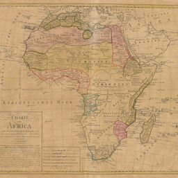
Charte von Africa
Permalink
https://digital.library.illinois.edu/items/4c1c6970-e946-0133-1d3d-0050569601ca-5
This item is in the public domain.
Descriptive Information
| Title | Charte von Africa |
| Creator | Gufsefeld, F. Louis |
| Date | 1797 |
| Dimensions | 46.2 x 52 cm |
| Place of Publication | Germany |
| Cartographic Scale | 1:20,450,000 |
| Coverage-Spatial | Africa |
| Genre | Maps |
| Source | Atlas compendiarivs, plate 49. |
| Physical Location | rbx |
| Map No. in Bassett and Scheven Bibliography | 131 |
| Call Number | XF_912H751AT |
| Map ID | afm0000131 |
| Rights | No Copyright - United States |
| Rights Description | This item is in the public domain. |
| Collection Title | Maps of Africa to 1900 |
| Repository | Rare Book & Manuscript Library |
| Type | Cartographic material |
| Collection | Maps of Africa to 1900 |
Download Options
|
Charte von Africa |
Contact us
for questions and to provide feedback.