
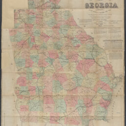
Lloyd's topographical map of Georgia from state surveys before the war showing railways, stations, villages, mills, &c. / J.T. Lloyd, publisher
Permalink
https://digital.library.illinois.edu/items/4c37aac0-0eca-013c-47d9-02d0d7bfd6e4-4
This item is in the public domain.
Descriptive Information
| Title | Lloyd's topographical map of Georgia from state surveys before the war showing railways, stations, villages, mills, &c. / J.T. Lloyd, publisher |
| Creator | Lloyd, James T. |
| Scale | Scale approximately 1:580,000 |
| Place of Publication | New York (N.Y.) |
| Publisher | Lloyd, J.T. |
| Date of Publication | 1864 |
| Extent | 1 map : hand colored |
| Dimensions | 91 x 78 cm |
| Notes |
|
| Coverage-Spatial | Georgia |
| Language | English |
| Genre | Maps |
| Rights | No Copyright - United States |
| Rights Description | This item is in the public domain. |
| Type | Cartographic material |
| Repository | Map Library |
| Local Bib ID | 99955337993805899 |
| Collection Title | Civil War Maps |
| Collection | Civil War Maps |
Download Options
|
Lloyd's topographical map of Georgia from state surveys before the war showing railways, stations, villages, mills, &c. / J.T. Lloyd, publisher |
Contact us
for questions and to provide feedback.