
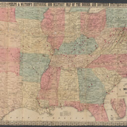
Phelps & Watson's historical and military map of the border & southern states
Permalink
https://digital.library.illinois.edu/items/4c5904d0-0eca-013c-47d9-02d0d7bfd6e4-3
This item is in the public domain.
Descriptive Information
| Title | Phelps & Watson's historical and military map of the border & southern states |
| Creator | Phelps & Watson |
| Scale | Scale approximately 1:2,534,400 |
| Place of Publication | New York (N.Y.) |
| Publisher | Watson, Gaylord |
| Date of Publication | |
| Extent | 1 map : color |
| Dimensions | 64 x 92 cm |
| Notes |
|
| Coverage-Spatial | |
| Language | English |
| Associated Entities | Watson, Gaylord |
| Genre | |
| Rights | No Copyright - United States |
| Rights Description | This item is in the public domain. |
| Type | Cartographic material |
| Repository | Map Library |
| Local Bib ID | 99955338016305899 |
| Collection Title | Civil War Maps |
| Collection | Civil War Maps |
Download Options
|
Phelps & Watson's historical and military map of the border & southern states |
Contact us
for questions and to provide feedback.