
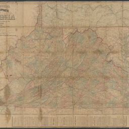
Lloyd's official map of the state of Virginia : from actual surveys by order of the executive, 1828 & 1859
Permalink
https://digital.library.illinois.edu/items/4c5fb9f0-0eca-013c-47d9-02d0d7bfd6e4-f
This item is in the public domain.
Descriptive Information
| Title | Lloyd's official map of the state of Virginia : from actual surveys by order of the executive, 1828 & 1859 |
| Creator | Lloyd, James T. |
| Scale | Scale approximately 1:650,000 |
| Place of Publication | New York (N.Y.) |
| Publisher | Lloyd, J.T. |
| Date of Publication | 1861 |
| Extent | 1 map : hand colored, sectioned and mounted on cloth |
| Dimensions | 77 x 122 cm, sections 18 x 12 cm or smaller |
| Notes |
|
| Coverage-Spatial | Virginia |
| Language | English |
| Subject | Broadsides |
| Genre | Maps |
| Rights | No Copyright - United States |
| Rights Description | This item is in the public domain. |
| Type | Cartographic material |
| Repository | Map Library |
| Local Bib ID | 99955338126305899 |
| Collection Title | Civil War Maps |
| Collection | Civil War Maps |
Download Options
|
Lloyd's official map of the state of Virginia : from actual surveys by order of the executive, 1828 & 1859 |
Contact us
for questions and to provide feedback.