


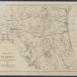
Northern part of Florida / compiled and published at the United States Coast Survey Office ; drawn by H. Lindenkohl
Permalink
https://digital.library.illinois.edu/items/4c70b2a0-0eca-013c-47d9-02d0d7bfd6e4-0
This item is in the public domain.
Descriptive Information
| Title | Northern part of Florida / compiled and published at the United States Coast Survey Office ; drawn by H. Lindenkohl |
| Creator | Lindenkohl, H. (Henry) |
| Scale | Scale [1:633,600]. 1 in. = 10 miles |
| Place of Publication | Washington (D.C.) |
| Publisher | United States Coast Survey |
| Date of Publication | 1864 |
| Extent | 1 map |
| Dimensions | 42 x 58 cm |
| Notes |
|
| Coverage-Spatial | Florida |
| Language | English |
| Associated Entities | |
| Genre | Maps |
| Rights | No Copyright - United States |
| Rights Description | This item is in the public domain. |
| Type | Cartographic material |
| Repository | Map Library |
| Local Bib ID | 99955338216005899 |
| Collection Title | Civil War Maps |
| Collection | Civil War Maps |
Download Options
|
Northern part of Florida / compiled and published at the United States Coast Survey Office ; drawn by H. Lindenkohl |
Contact us
for questions and to provide feedback.