


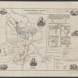
Topographical sketch of the battle field of Stone River [Dec. 31, 1862] / Drawn by Lt. O.R. Dahl, Topographical Engineer, 2nd Brigade, 1st Div.
Permalink
https://digital.library.illinois.edu/items/4c7d6ae0-0eca-013c-47d9-02d0d7bfd6e4-5
This item is in the public domain.
Descriptive Information
| Title | Topographical sketch of the battle field of Stone River [Dec. 31, 1862] / Drawn by Lt. O.R. Dahl, Topographical Engineer, 2nd Brigade, 1st Div. |
| Creator | Dahl, O. R. (Ole Rasmussen), 1817-1882 |
| Scale | Scale approximately 1:25,100 |
| Place of Publication | Chicago (Ill.) |
| Publisher | Shober's, Chas. |
| Date of Publication | 1863-1864 |
| Extent | 1 map : color |
| Dimensions | 34 x 45 cm |
| Notes |
|
| Coverage-Spatial | |
| Language | English |
| Subject | Battle of Stones River (Murfreesboro, Tennessee : 1862-1863) |
| Associated Entities | Shober, Charles |
| Genre | Maps |
| Rights | No Copyright - United States |
| Rights Description | This item is in the public domain. |
| Type | Cartographic material |
| Repository | Map Library |
| Local Bib ID | 99955338311605899 |
| Collection Title | Civil War Maps |
| Collection | Civil War Maps |
Download Options
|
Topographical sketch of the battle field of Stone River [Dec. 31, 1862] / Drawn by Lt. O.R. Dahl, Topographical Engineer, 2nd Brigade, 1st Div. |
Contact us
for questions and to provide feedback.