
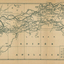
Mission Salesses (Guine Franse,) Carte des voies de communication de Konarkry au Niger
Permalink
https://digital.library.illinois.edu/items/4cbeae00-e946-0133-1d3d-0050569601ca-0
This item is in the public domain.
Descriptive Information
| Title | Mission Salesses (Guine Franse,) Carte des voies de communication de Konarkry au Niger |
| Creator | Salesses, Grrie |
| Date | 1899 |
| Dimensions | 18.7 x 45.3 cm |
| Place of Publication | France |
| Cartographic Scale | 1:1,000,000 |
| Coverage-Spatial | Africa, West |
| Genre | Maps |
| Color | Bitonal |
| Source | Bulletin de la Société de géographie, ser. 7, V. 20, after p. 490. |
| Physical Location | stx |
| Map No. in Bassett and Scheven Bibliography | 2390 |
| Call Number | 910_6SOGEASER_7 |
| Map ID | afm0002390 |
| Rights | No Copyright - United States |
| Rights Description | This item is in the public domain. |
| Collection Title | Maps of Africa to 1900 |
| Repository | Rare Book & Manuscript Library |
| Type | Cartographic material |
| Collection | Maps of Africa to 1900 |
Download Options
|
Mission Salesses (Guine Franse,) Carte des voies de communication de Konarkry au Niger |
Contact us
for questions and to provide feedback.