
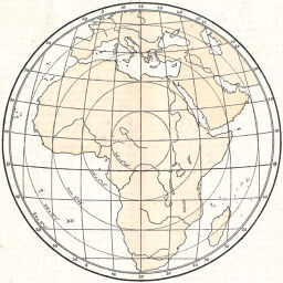
Flachentreue Azimutal Projektion für die Karte von Afrika
Permalink
https://digital.library.illinois.edu/items/4ec27430-e946-0133-1d3d-0050569601ca-9
This item is in the public domain.
Descriptive Information
| Title | Flachentreue Azimutal Projektion für die Karte von Afrika |
| Creator | Hammer, E. (Ernst), 1858- |
| Date | 1894 |
| Dimensions | 12.9 x 12.9 cm |
| Cartographic Scale | 1:80,000,000 |
| Notes | Shows radial distances in DDMMSS from 10N 20E degrees. |
| Coverage-Spatial | Africa |
| Subject | Mathematical geography |
| Genre | Maps |
| Language | German |
| Color | Hand colored |
| Technique | Lithography |
| Source | Petermanns geographische Mitteilungen., V. 40, p. 115. |
| Physical Location | stx |
| Map No. in Bassett and Scheven Bibliography | 425 |
| Call Number | Q_910_5PE |
| Map ID | afm0000425 |
| Rights | No Copyright - United States |
| Rights Description | This item is in the public domain. |
| Collection Title | Maps of Africa to 1900 |
| Repository | Rare Book & Manuscript Library |
| Type | Cartographic material |
| Collection | Maps of Africa to 1900 |
Download Options
|
Flachentreue Azimutal Projektion für die Karte von Afrika |
Contact us
for questions and to provide feedback.