
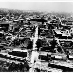
Aerial View of Buildings Taken from a Point North of the Intersection of the Railway Tracks and Walnut Street
Permalink
https://digital.library.illinois.edu/items/4ed0d180-1eab-0134-1d73-0050569601ca-8
All images are provided for personal and educational use. Users planning to reproduce/publish images in books, articles, exhibits, videos, electronic transmission or other media must request permission. For more information please contact the Champaign County Historical Archives at The Urbana Free Library: http://urbanafreelibrary.org/
Descriptive Information
| Building Name | Aerial View of Buildings Taken from a Point North of the Intersection of the Railway Tracks and Walnut Street |
| City | Champaign (Ill.) |
| Subject | Aerial photographs |
| Description | Take from a point north of the intersection of the Cleveland, Cincinnati, Chicago, and St. Louis Railway Co. tracks and Walnut Street, looking south. |
| Type | Still image |
| Coverage-Temporal | 1910-1920 |
| Coverage-Spatial | Champaign (Ill.) |
| Source | Champaign County Historical Society Prints |
| Rights | In Copyright - Educational Use Permitted |
| Rights Description | All images are provided for personal and educational use. Users planning to reproduce/publish images in books, articles, exhibits, videos, electronic transmission or other media must request permission. For more information please contact the Champaign County Historical Archives at The Urbana Free Library: http://urbanafreelibrary.org/ |
| Repository | Champaign County Historical Archives (Urbana Free Library) |
| Collection Title | Champaign-Urbana Historic Built Environment |
| Collection | Champaign-Urbana Historic Built Environment |
Download Options
|
Aerial View of Buildings Taken from a Point North of the Intersection of the Railway Tracks and Walnut Street |
Contact us
for questions and to provide feedback.