
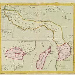
Guinée, Congo, Madagascar
Permalink
https://digital.library.illinois.edu/items/4ee87230-e946-0133-1d3d-0050569601ca-e
This item is in the public domain.
Descriptive Information
| Title | Guinée, Congo, Madagascar |
| Creator | Chatelain, Henri Abraham |
| Date | 1710-1719 |
| Dimensions | 31.3 x 33.9 cm |
| Cartographic Scale | 1:14,800,000 |
| Coverage-Spatial | Africa, West |
| Genre | Maps |
| Source | Loose sheet |
| Physical Location | rbx |
| Map No. in Bassett and Scheven Bibliography | 2141 |
| Call Number | G8835171-?_G8 |
| Map ID | afm0002141 |
| Rights | No Copyright - United States |
| Rights Description | This item is in the public domain. |
| Collection Title | Maps of Africa to 1900 |
| Repository | Rare Book & Manuscript Library |
| Type | Cartographic material |
| Collection | Maps of Africa to 1900 |
Download Options
|
Guinée, Congo, Madagascar |
Contact us
for questions and to provide feedback.