
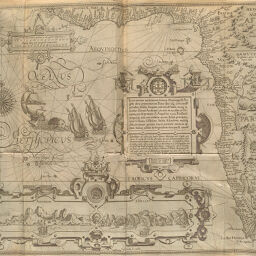
Typus orarum maritimarum Guinae, Manicongo, & Angola ultra promontorium Bonae Spei...
Permalink
https://digital.library.illinois.edu/items/4f3ab780-e946-0133-1d3d-0050569601ca-0
This item is in the public domain.
Descriptive Information
| Title | Typus orarum maritimarum Guinae, Manicongo, & Angola ultra promontorium Bonae Spei... |
| Creator | Langren, Arnold Florent van, 1580-1644 |
| Date | 1623 |
| Dimensions | 38.9 x 52.5 cm |
| Cartographic Scale | 1:13,000,000 |
| Coverage-Spatial | Africa, West |
| Genre | Maps |
| Source | Itinerarium, p. 176. |
| Physical Location | rbx |
| Map No. in Bassett and Scheven Bibliography | 2114 |
| Call Number | XQ_910_4L65I |
| Map ID | afm0002114 |
| Rights | No Copyright - United States |
| Rights Description | This item is in the public domain. |
| Collection Title | Maps of Africa to 1900 |
| Repository | Rare Book & Manuscript Library |
| Type | Cartographic material |
| Collection | Maps of Africa to 1900 |
Download Options
|
Typus orarum maritimarum Guinae, Manicongo, & Angola ultra promontorium Bonae Spei... |
Contact us
for questions and to provide feedback.