
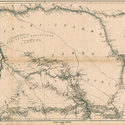
Originalkarte des Sankuru-Stromes und Seiner Nebenflüsse…
Permalink
https://digital.library.illinois.edu/items/505ab370-e946-0133-1d3d-0050569601ca-5
This item is in the public domain.
Descriptive Information
| Title | Originalkarte des Sankuru-Stromes und Seiner Nebenflüsse… |
| Creator | Hassenstein, Bruno |
| Date | 1888 |
| Dimensions | 47.7 x 73.2 cm |
| Place of Publication | Germany |
| Cartographic Scale | 1:600,000 |
| Notes | Includes 2 inset maps: Plan von Luebo (1:60,000) -- Die Wissman Fälle (1:100,000) -- [Wolf Fall region]. |
| Coverage-Spatial | Congo |
| Subject | |
| Genre | Maps |
| Language | German |
| Color | Printed color |
| Technique | Lithography |
| Source | Petermanns geographische Mitteilungen, V. 34, plate 12. |
| Physical Location | stx |
| Map No. in Bassett and Scheven Bibliography | 2008 |
| Call Number | Q_910_5PE |
| Map ID | afm0002008 |
| Rights | No Copyright - United States |
| Rights Description | This item is in the public domain. |
| Collection Title | Maps of Africa to 1900 |
| Repository | Rare Book & Manuscript Library |
| Type | Cartographic material |
| Collection | Maps of Africa to 1900 |
Download Options
|
Originalkarte des Sankuru-Stromes und Seiner Nebenflüsse… |
Contact us
for questions and to provide feedback.