


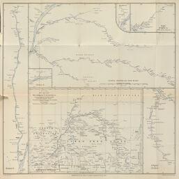
Preliminary Map and Plans of the Congo and its Tributaries. Surveyed by the Rev. George Grefell in the B.M.S. Steamer Peace
Permalink
https://digital.library.illinois.edu/items/50e6b2f0-e946-0133-1d3d-0050569601ca-f
This item is in the public domain.
Descriptive Information
| Title | Preliminary Map and Plans of the Congo and its Tributaries. Surveyed by the Rev. George Grefell in the B.M.S. Steamer Peace |
| Creator | Sharbau, H. (Henry) |
| Date | 1886 |
| Dimensions | 21.3 x 29 cm |
| Cartographic Scale | 1:7,000,000 |
| Coverage-Spatial | Africa, Central |
| Genre | Maps |
| Source | Proceedings of the Royal Geographical Society, V. 8, No. 10, after p. 680. |
| Physical Location | rbx |
| Map No. in Bassett and Scheven Bibliography | 1963 |
| Call Number | 910_6RLn_s_ |
| Map ID | afm0001963 |
| Rights | No Copyright - United States |
| Rights Description | This item is in the public domain. |
| Collection Title | Maps of Africa to 1900 |
| Repository | Rare Book & Manuscript Library |
| Type | Cartographic material |
| Collection | Maps of Africa to 1900 |
Download Options
|
Preliminary Map and Plans of the Congo and its Tributaries. Surveyed by the Rev. George Grefell in the B.M.S. Steamer Peace |
Contact us
for questions and to provide feedback.