
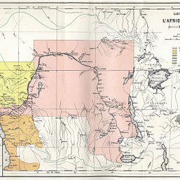
Carte Politique de l'Afrique Centrale
Permalink
https://digital.library.illinois.edu/items/50f65540-e946-0133-1d3d-0050569601ca-9
This item is in the public domain.
Descriptive Information
| Title | Carte Politique de l'Afrique Centrale |
| Creator | Institut national de géographie (Brussels, Belgium) |
| Date | 1885 |
| Dimensions | 25.1 x 37.5 cm |
| Place of Publication | Belgium |
| Cartographic Scale | 1:10,000,000 |
| Notes | Includes inset maps of Africa and Belgium. |
| Coverage-Spatial | Congo (Democratic Republic) |
| Subject | |
| Genre | Maps |
| Language | French |
| Color | Printed color |
| Technique | Lithography |
| Source | Bulletin de l'annèe, V. 7, between pp. 80-81. |
| Physical Location | stx |
| Map No. in Bassett and Scheven Bibliography | 1939 |
| Call Number | 910_6SOI |
| Map ID | afm0001939 |
| Rights | No Copyright - United States |
| Rights Description | This item is in the public domain. |
| Collection Title | Maps of Africa to 1900 |
| Repository | Rare Book & Manuscript Library |
| Type | Cartographic material |
| Collection | Maps of Africa to 1900 |
Download Options
|
Carte Politique de l'Afrique Centrale |
Contact us
for questions and to provide feedback.