


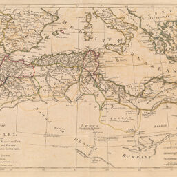
Map of Barbary, containing the Kingdoms of Morocco, Fez, Algier, Tunis and Tripoli with the adjacent countries
Permalink
https://digital.library.illinois.edu/items/5153e530-e946-0133-1d3d-0050569601ca-f
This item is in the public domain.
Descriptive Information
| Title | Map of Barbary, containing the Kingdoms of Morocco, Fez, Algier, Tunis and Tripoli with the adjacent countries |
| Creator | Dunn, Samuel, -1794 |
| Date | 1774 |
| Dimensions | 30.8 x 44 cm |
| Place of Publication | England |
| Cartographic Scale | 1:8,750,000 |
| Coverage-Spatial | Africa, North |
| Genre | Maps |
| Source | New Atlas, plate 37. |
| Physical Location | rbx |
| Map No. in Bassett and Scheven Bibliography | 633 |
| Call Number | XF_912D92N |
| Map ID | afm0000633 |
| Rights | No Copyright - United States |
| Rights Description | This item is in the public domain. |
| Collection Title | Maps of Africa to 1900 |
| Repository | Rare Book & Manuscript Library |
| Type | Cartographic material |
| Collection | Maps of Africa to 1900 |
Download Options
|
Map of Barbary, containing the Kingdoms of Morocco, Fez, Algier, Tunis and Tripoli with the adjacent countries |
Contact us
for questions and to provide feedback.