
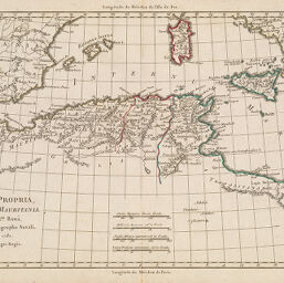
Africa Propria Numidia et Mauritania
Permalink
https://digital.library.illinois.edu/items/515ce8b0-e946-0133-1d3d-0050569601ca-d
This item is in the public domain.
Descriptive Information
| Title | Africa Propria Numidia et Mauritania |
| Creator | Bonne, Rigobert |
| Date | 1780 |
| Dimensions | 26.7 x 37.9 cm |
| Cartographic Scale | 1:7,000,000 |
| Coverage-Spatial | Africa, North |
| Genre | Maps |
| Source | Loose sheet |
| Physical Location | rbx |
| Map No. in Bassett and Scheven Bibliography | 636 |
| Call Number | G8320_S11780_B6 |
| Map ID | afm0000636 |
| Rights | No Copyright - United States |
| Rights Description | This item is in the public domain. |
| Collection Title | Maps of Africa to 1900 |
| Repository | Rare Book & Manuscript Library |
| Type | Cartographic material |
| Collection | Maps of Africa to 1900 |
Download Options
|
Africa Propria Numidia et Mauritania |
Contact us
for questions and to provide feedback.