
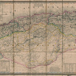
Algérie
Permalink
https://digital.library.illinois.edu/items/5258fc50-e946-0133-1d3d-0050569601ca-0
This item is in the public domain.
Descriptive Information
| Title | Algérie |
| Creator | Dufour, A.-H. (Auguste-Henri), 1798-1865 |
| Date | 1856 |
| Dimensions | 58 x 83 cm |
| Cartographic Scale | 1:1,400,000 |
| Notes | Relief shown by hachures. Paris meridian. Includes tables showing distance, population, and common Arabic phrases. |
| Coverage-Spatial | Algeria |
| Subject | |
| Genre | Maps |
| Language | French |
| Color | Hand colored |
| Technique | Etched or engraved |
| Source | Loose sheet |
| Physical Location | max |
| Map No. in Bassett and Scheven Bibliography | 712 |
| Call Number | G82401856_D8 |
| Map ID | afm0000712 |
| Rights | No Copyright - United States |
| Rights Description | This item is in the public domain. |
| Collection Title | Maps of Africa to 1900 |
| Repository | Rare Book & Manuscript Library |
| Type | Cartographic material |
| Collection | Maps of Africa to 1900 |
Download Options
|
Algérie |
Contact us
for questions and to provide feedback.