


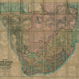
Juta's Map of South Africa
Permalink
https://digital.library.illinois.edu/items/52b50e10-e946-0133-1d3d-0050569601ca-0
This item is in the public domain.
Descriptive Information
| Title | Juta's Map of South Africa |
| Creator | Juta and Company |
| Date | 1896 |
| Dimensions | 88 x 122 cm |
| Cartographic Scale | 1:2,534,400 |
| Coverage-Spatial | Africa, Southern |
| Genre | Maps |
| Color | Printed color |
| Technique | Lithography |
| Source | Loose sheet |
| Physical Location | max |
| Map No. in Bassett and Scheven Bibliography | 1792 |
| Call Number | G84801896_J8 |
| Map ID | afm0001792 |
| Rights | No Copyright - United States |
| Rights Description | This item is in the public domain. |
| Collection Title | Maps of Africa to 1900 |
| Repository | Rare Book & Manuscript Library |
| Type | Cartographic material |
| Collection | Maps of Africa to 1900 |
Download Options
|
Juta's Map of South Africa |
Contact us
for questions and to provide feedback.