
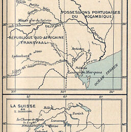
Carte des Régions parcourues par les Missionnaires de la Mission romande...
Permalink
https://digital.library.illinois.edu/items/52e1d850-e946-0133-1d3d-0050569601ca-0
This item is in the public domain.
Descriptive Information
| Title | Carte des Régions parcourues par les Missionnaires de la Mission romande... |
| Creator | Schlaefli, E. H. |
| Date | 1892 |
| Dimensions | 10.7 x 10.5 cm |
| Place of Publication | Switzerland |
| Cartographic Scale | 1:5,000,000 |
| Notes | Elevations shown by spot heights. Includes ancillary map showing Switzerland at same scale. |
| Coverage-Spatial | Transvaal (Colony) |
| Subject | |
| Genre | Maps |
| Language | French |
| Color | Printed color |
| Technique | Lithography |
| Source | Bulletin de la Société de Géographie de Toulouse, V. 7, p. 181. |
| Physical Location | stx |
| Map No. in Bassett and Scheven Bibliography | 1765 |
| Call Number | 910_6SON |
| Map ID | afm0001765 |
| Rights | No Copyright - United States |
| Rights Description | This item is in the public domain. |
| Collection Title | Maps of Africa to 1900 |
| Repository | Rare Book & Manuscript Library |
| Type | Cartographic material |
| Collection | Maps of Africa to 1900 |
Download Options
|
Carte des Régions parcourues par les Missionnaires de la Mission romande... |
Contact us
for questions and to provide feedback.