
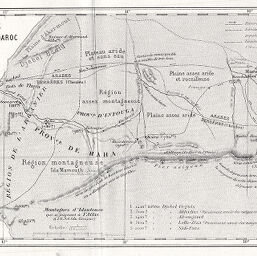
Itinéraire de Mogador a Maroc par B. Balansa 1867
Permalink
https://digital.library.illinois.edu/items/52ea36f0-e946-0133-1d3d-0050569601ca-2
This item is in the public domain.
Descriptive Information
| Title | Itinéraire de Mogador a Maroc par B. Balansa 1867 |
| Date | 1868 |
| Dimensions | 11.2 x 18.2 cm |
| Place of Publication | France |
| Cartographic Scale | 1:600,000 |
| Notes | On same page as ID No. 767. |
| Coverage-Spatial | Africa, North |
| Genre | Maps |
| Color | Bitonal |
| Technique | Lithography |
| Source | Bulletin de la Société de géographie, ser. 5, V. 15, between pp. 416-417. |
| Physical Location | stx |
| Map No. in Bassett and Scheven Bibliography | 766 |
| Call Number | 910_6SOGEASER_5 |
| Map ID | afm0000766 |
| Rights | No Copyright - United States |
| Rights Description | This item is in the public domain. |
| Collection Title | Maps of Africa to 1900 |
| Repository | Rare Book & Manuscript Library |
| Type | Cartographic material |
| Collection | Maps of Africa to 1900 |
Download Options
|
Itinéraire de Mogador a Maroc par B. Balansa 1867 |
Contact us
for questions and to provide feedback.