
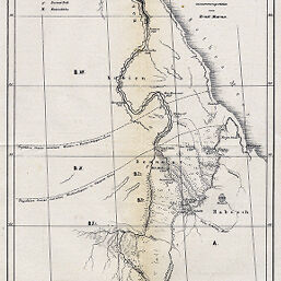
Schematische Übersichts Karte der Boden und Plantss Verhältnifse Nord-Ost-Afrikas
Permalink
https://digital.library.illinois.edu/items/52f17360-e946-0133-1d3d-0050569601ca-f
This item is in the public domain.
Descriptive Information
| Title | Schematische Übersichts Karte der Boden und Plantss Verhältnifse Nord-Ost-Afrikas |
| Creator | Marno, Ernst, 1844-1883 |
| Date | 1870 |
| Dimensions | 32.5 x 18.3 cm |
| Place of Publication | Austria |
| Cartographic Scale | 1:11,500,000 |
| Coverage-Spatial | Nile River Valley |
| Subject | |
| Genre | Maps |
| Language | German |
| Color | Bitonal |
| Technique | Lithography |
| Source | Mitteilungen der Österreichischen Geographischen Gesellschaft, V. 13, between pp. 640-641. |
| Physical Location | stx |
| Map No. in Bassett and Scheven Bibliography | 772 |
| Call Number | 910_5GEOW |
| Map ID | afm0000772 |
| Rights | No Copyright - United States |
| Rights Description | This item is in the public domain. |
| Collection Title | Maps of Africa to 1900 |
| Repository | Rare Book & Manuscript Library |
| Type | Cartographic material |
| Collection | Maps of Africa to 1900 |
Download Options
|
Schematische Übersichts Karte der Boden und Plantss Verhältnifse Nord-Ost-Afrikas |
Contact us
for questions and to provide feedback.