
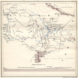
Chotts Algériens se rapportant au projet de mer intérieure
Permalink
https://digital.library.illinois.edu/items/53928ba0-e946-0133-1d3d-0050569601ca-b
This item is in the public domain.
Descriptive Information
| Title | Chotts Algériens se rapportant au projet de mer intérieure |
| Creator | Revue Géographique Internationale |
| Date | 1878 |
| Dimensions | 15.2 x 15.1 cm |
| Place of Publication | France |
| Cartographic Scale | Scale not given |
| Notes | Relief shown by hachures. Includes 1 inset elevation profile. |
| Coverage-Spatial | Algeria |
| Subject | |
| Genre | Maps |
| Language | French |
| Color | Printed color |
| Technique | Lithography |
| Source | Revue géographique internationale, V. 3, between pp. 40-41. |
| Physical Location | stos |
| Map No. in Bassett and Scheven Bibliography | 816 |
| Call Number | 910_5REGI |
| Map ID | afm0000816 |
| Rights | No Copyright - United States |
| Rights Description | This item is in the public domain. |
| Collection Title | Maps of Africa to 1900 |
| Repository | Rare Book & Manuscript Library |
| Type | Cartographic material |
| Collection | Maps of Africa to 1900 |
Download Options
|
Chotts Algériens se rapportant au projet de mer intérieure |
Contact us
for questions and to provide feedback.