
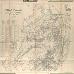
Map of the Transvaal and the Surrounding Territories
Permalink
https://digital.library.illinois.edu/items/53a8fb70-e946-0133-1d3d-0050569601ca-9
This item is in the public domain.
Descriptive Information
| Title | Map of the Transvaal and the Surrounding Territories |
| Creator | Jeppe, Frederick |
| Date | 1877 |
| Dimensions | 58.1 x 56.6 cm |
| Place of Publication | England |
| Cartographic Scale | 1:1,850,000 |
| Coverage-Spatial | Africa, Southern |
| Genre | Maps |
| Source | Journal of the Royal Geographic Society, V. 47, between pp. 216-217. |
| Physical Location | rbx |
| Map No. in Bassett and Scheven Bibliography | 1678 |
| Call Number | 910_6ROJ |
| Map ID | afm0001678 |
| Rights | No Copyright - United States |
| Rights Description | This item is in the public domain. |
| Collection Title | Maps of Africa to 1900 |
| Repository | Rare Book & Manuscript Library |
| Type | Cartographic material |
| Collection | Maps of Africa to 1900 |
Download Options
|
Map of the Transvaal and the Surrounding Territories |
Contact us
for questions and to provide feedback.