
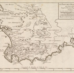
Le Pays des Hottentots aux Environs du Cap de Bonne Esperance
Permalink
https://digital.library.illinois.edu/items/5461ba90-e946-0133-1d3d-0050569601ca-e
This item is in the public domain.
Descriptive Information
| Title | Le Pays des Hottentots aux Environs du Cap de Bonne Esperance |
| Creator | Bellin, Jacques Nicolas |
| Date | 1780-1789 |
| Dimensions | 24.6 x 34.6 cm |
| Cartographic Scale | 1:1,445,000 |
| Coverage-Spatial | Africa, Southern |
| Genre | Maps |
| Source | Loose sheet |
| Physical Location | rbx |
| Map No. in Bassett and Scheven Bibliography | 1611 |
| Call Number | G8610178-_B4 |
| Map ID | afm0001611 |
| Rights | No Copyright - United States |
| Rights Description | This item is in the public domain. |
| Collection Title | Maps of Africa to 1900 |
| Repository | Rare Book & Manuscript Library |
| Type | Cartographic material |
| Collection | Maps of Africa to 1900 |
Download Options
|
Le Pays des Hottentots aux Environs du Cap de Bonne Esperance |
Contact us
for questions and to provide feedback.