
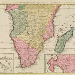
Carte de Afrique Meridionale, ou pays Entre la Ligne & le Cap de Bonne Esperance et Isle de Madagascar
Permalink
https://digital.library.illinois.edu/items/5468bb80-e946-0133-1d3d-0050569601ca-e
This item is in the public domain.
Descriptive Information
| Title | Carte de Afrique Meridionale, ou pays Entre la Ligne & le Cap de Bonne Esperance et Isle de Madagascar |
| Creator | L'Isle, Guillaume de, 1675-1726 |
| Date | 1792 |
| Dimensions | 51 x 58 cm |
| Cartographic Scale | 1:9,250,000 |
| Coverage-Spatial | Africa, Southern |
| Genre | Maps |
| Source | Loose sheet |
| Physical Location | rbx |
| Map No. in Bassett and Scheven Bibliography | 1614 |
| Call Number | G85801792_E4 |
| Map ID | afm0001614 |
| Rights | No Copyright - United States |
| Rights Description | This item is in the public domain. |
| Collection Title | Maps of Africa to 1900 |
| Repository | Rare Book & Manuscript Library |
| Type | Cartographic material |
| Collection | Maps of Africa to 1900 |
Download Options
|
Carte de Afrique Meridionale, ou pays Entre la Ligne & le Cap de Bonne Esperance et Isle de Madagascar |
Contact us
for questions and to provide feedback.