
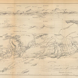
Route de Fez à Oudjda par le Cte. M. de Chavagnac 7-17 Février 1881
Permalink
https://digital.library.illinois.edu/items/549984b0-e946-0133-1d3d-0050569601ca-8
This item is in the public domain.
Descriptive Information
| Title | Route de Fez à Oudjda par le Cte. M. de Chavagnac 7-17 Février 1881 |
| Creator | Hansen, Jules, 1849-1931 |
| Date | 1887 |
| Dimensions | 24.4 x 37.9 cm |
| Place of Publication | France |
| Cartographic Scale | 1:800,000 |
| Notes | Includes panoramic views of mountain ranges. |
| Coverage-Spatial | Africa, North |
| Genre | Maps |
| Source | Bulletin de la Société de géographie, ser. 7, V. 19, between pp. 438-439. |
| Physical Location | stx |
| Map No. in Bassett and Scheven Bibliography | 897 |
| Map ID | afm0000897 |
| Rights | No Copyright - United States |
| Rights Description | This item is in the public domain. |
| Collection Title | Maps of Africa to 1900 |
| Repository | Rare Book & Manuscript Library |
| Type | Cartographic material |
| Collection | Maps of Africa to 1900 |
Download Options
|
Route de Fez à Oudjda par le Cte. M. de Chavagnac 7-17 Février 1881 |
Contact us
for questions and to provide feedback.