
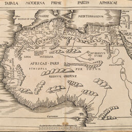
Tabvla Moderna Prime Partis Aphricae
Permalink
https://digital.library.illinois.edu/items/55118f60-e946-0133-1d3d-0050569601ca-d
This item is in the public domain.
Descriptive Information
| Title | Tabvla Moderna Prime Partis Aphricae |
| Creator | Ptolemaeus, Claudius |
| Date | 1513 |
| Dimensions | 41.5 x 57.5 cm |
| Place of Publication | Germany |
| Cartographic Scale | 1:11,000,000 |
| Coverage-Spatial | Africa, Southern |
| Genre | Maps |
| Source | Geographiae, plate 12 in supplement. |
| Physical Location | rbx |
| Map No. in Bassett and Scheven Bibliography | 1567 |
| Call Number |
|
| Map ID | afm0001567 |
| Rights | No Copyright - United States |
| Rights Description | This item is in the public domain. |
| Collection Title | Maps of Africa to 1900 |
| Repository | Rare Book & Manuscript Library |
| Type | Cartographic material |
| Collection | Maps of Africa to 1900 |
Download Options
|
Tabvla Moderna Prime Partis Aphricae |
Contact us
for questions and to provide feedback.