
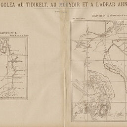
D'el Goléa au Tidikelt, au Mouydir et à l'Adrar Ahnet
Permalink
https://digital.library.illinois.edu/items/5518fdb0-e946-0133-1d3d-0050569601ca-6
This item is in the public domain.
Descriptive Information
| Title | D'el Goléa au Tidikelt, au Mouydir et à l'Adrar Ahnet |
| Creator | Bissuel, H. (Henri) |
| Date | 1890 |
| Dimensions | 21.4 x 18.1 cm |
| Place of Publication | France |
| Cartographic Scale | 1:2,500,000 |
| Notes | Two maps on 1 sheet. Paris meridian. |
| Coverage-Spatial | Algeria |
| Subject | |
| Genre | Maps |
| Language | French |
| Color | Printed color |
| Technique | Lithography |
| Source | Revue géographique internationale, V. 15, between pp. 236-237. |
| Physical Location | stos |
| Map No. in Bassett and Scheven Bibliography | 928 |
| Call Number | 910_5REGI |
| Map ID | afm0000928 |
| Rights | No Copyright - United States |
| Rights Description | This item is in the public domain. |
| Collection Title | Maps of Africa to 1900 |
| Repository | Rare Book & Manuscript Library |
| Type | Cartographic material |
| Collection | Maps of Africa to 1900 |
Download Options
|
D'el Goléa au Tidikelt, au Mouydir et à l'Adrar Ahnet |
Contact us
for questions and to provide feedback.