
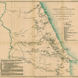
Egypt Eastern Desert or Northern Etbai
Permalink
https://digital.library.illinois.edu/items/553ff950-e946-0133-1d3d-0050569601ca-4
This item is in the public domain.
Descriptive Information
| Title | Egypt Eastern Desert or Northern Etbai |
| Creator | Floyer, E. A. |
| Date | 1891 |
| Dimensions | 43.1 x 45.5 cm |
| Place of Publication | England |
| Cartographic Scale | 1:760,000 |
| Notes | Relief shown by contoured hachures and spot heights. Table of wells and water resources and text in lower left corner. |
| Coverage-Spatial | Nile River |
| Subject | |
| Genre | Maps |
| Language | English |
| Color | Printed color |
| Technique | Lithography |
| Source | The Geographical Journal, V. 1, between pp. 480-481. |
| Physical Location | stx |
| Map No. in Bassett and Scheven Bibliography | 939 |
| Call Number | 910_5GJ |
| Map ID | afm0000939 |
| Rights | No Copyright - United States |
| Rights Description | This item is in the public domain. |
| Collection Title | Maps of Africa to 1900 |
| Repository | Rare Book & Manuscript Library |
| Type | Cartographic material |
| Collection | Maps of Africa to 1900 |
Download Options
|
Egypt Eastern Desert or Northern Etbai |
Contact us
for questions and to provide feedback.