
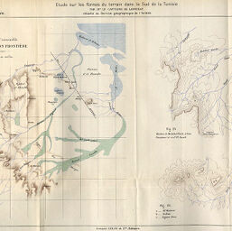
Etude sur les formes du dans le Sud de la Tunisie; Plan d'ensemble de la Région Frontière
Permalink
https://digital.library.illinois.edu/items/560624d0-e946-0133-1d3d-0050569601ca-8
This item is in the public domain.
Descriptive Information
| Title | Etude sur les formes du dans le Sud de la Tunisie; Plan d'ensemble de la Région Frontière |
| Creator | Larminat, Étienne de, 1863-1951 |
| Date | 1896 |
| Dimensions | 25.2 x 39.6 cm |
| Place of Publication | France |
| Cartographic Scale | 1:800,000 |
| Notes | Titles from caption and map. Relief shown by shading and contours. Includes 2 ancillary maps: Fig. 23 Hachem de Mechehed Fiasla, d'Oum Guerjoum (a) et d'El Aouadi -- Fig. 24. |
| Coverage-Spatial | Tataouine (Tunisia) |
| Subject | |
| Genre | Maps |
| Language | French |
| Color | Printed color |
| Technique | Lithography |
| Source | Annales de géographie : bulletin de la Société de géographie, V. 5, between pp. 448-449. |
| Physical Location | stx |
| Map No. in Bassett and Scheven Bibliography | 984 |
| Call Number | 910_5AN |
| Map ID | afm0000984 |
| Rights | No Copyright - United States |
| Rights Description | This item is in the public domain. |
| Collection Title | Maps of Africa to 1900 |
| Repository | Rare Book & Manuscript Library |
| Type | Cartographic material |
| Collection | Maps of Africa to 1900 |
Download Options
|
Etude sur les formes du dans le Sud de la Tunisie; Plan d'ensemble de la Région Frontière |
Contact us
for questions and to provide feedback.