
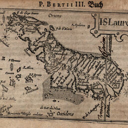
ISLauretij
Permalink
https://digital.library.illinois.edu/items/56f3cc50-e946-0133-1d3d-0050569601ca-c
This item is in the public domain.
Descriptive Information
| Title | ISLauretij |
| Creator | Bertius, Petrus, 1565-1629 |
| Date | 1612 |
| Dimensions | 8.6 x 12.3 cm |
| Place of Publication | Germany |
| Cartographic Scale | No scale |
| Coverage-Spatial | Africa, Eastern |
| Genre | Maps |
| Source | Geographischer, p. 606. |
| Physical Location | rbx |
| Map No. in Bassett and Scheven Bibliography | 1019 |
| Call Number | X910B46TGU |
| Map ID | afm0001019 |
| Rights | No Copyright - United States |
| Rights Description | This item is in the public domain. |
| Collection Title | Maps of Africa to 1900 |
| Repository | Rare Book & Manuscript Library |
| Type | Cartographic material |
| Collection | Maps of Africa to 1900 |
Download Options
|
ISLauretij |
Contact us
for questions and to provide feedback.