
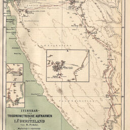
Itinerar-und Trigonometrische Aufnahmen in Lüderitzland von H. Pohle
Permalink
https://digital.library.illinois.edu/items/57656930-e946-0133-1d3d-0050569601ca-d
This item is in the public domain.
Descriptive Information
| Title | Itinerar-und Trigonometrische Aufnahmen in Lüderitzland von H. Pohle |
| Creator | Pohle, H. |
| Date | 1886 |
| Dimensions | 24.5 x 19.6 cm |
| Place of Publication | Germany |
| Cartographic Scale | 1:100,000 |
| Notes | Relief shown by form lines and spot heights. Includes 3 insets, labeled A-C, showing peak elevations in Guos, Harry's Trift, and Aus. |
| Coverage-Spatial | Namibia |
| Subject | |
| Genre | Maps |
| Language | German |
| Color | Printed color |
| Technique | Lithography |
| Source | Petermanns geographische Mitteilungen, V. 32, plate 11. |
| Physical Location | stx |
| Map No. in Bassett and Scheven Bibliography | 1723 |
| Call Number | Q_910_5PE |
| Map ID | afm0001723 |
| Rights | No Copyright - United States |
| Rights Description | This item is in the public domain. |
| Collection Title | Maps of Africa to 1900 |
| Repository | Rare Book & Manuscript Library |
| Type | Cartographic material |
| Collection | Maps of Africa to 1900 |
Download Options
|
Itinerar-und Trigonometrische Aufnahmen in Lüderitzland von H. Pohle |
Contact us
for questions and to provide feedback.